
Puerto Rico has 78 municipalities, organized into six regions: Metro, North, East, Central Mountains, South, and West. Each municipality name below links to the Government of Puerto Rico’s official municipal directory (pr.gov), verified as of July 2026.
Metro Region (San Juan Metropolitan Area) (Región Metro)
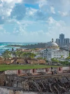 Puerto Rico’s Metro region is the island’s dense urban core and the arrival point for most visitors, wrapping the north-central coast around San Juan Bay. Its centerpiece is Old San Juan, a 500-year-old walled colonial district of pastel townhouses, blue-cobblestone streets, and the UNESCO-listed fortresses of El Morro and San Cristóbal guarding the Atlantic. Beyond the old city, the region delivers the beach-and-hotel strips of Condado and Isla Verde, the museums, street art, and nightlife of Santurce, and the Caribbean’s largest shopping mall at Plaza Las Américas. Geographically it sits on a narrow coastal plain threaded by bays, lagoons, and mangrove channels – with Guaynabo holding the ruins of Caparra, the island’s first Spanish settlement (1508), and Cataño facing the capital across the bay, home to the Bacardí rum distillery. Compact and walkable in its historic heart yet home to nearly a third of the island’s population, the Metro region concentrates more history, dining, and culture per square mile than anywhere else in Puerto Rico.
Municipalities
North Region (Región Norte)
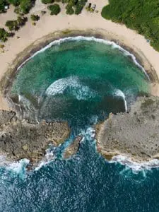 Stretching along the Atlantic between the Metro area and the northwest, the North region is defined by Puerto Rico’s spectacular karst country – a belt of limestone hills, or mogotes, riddled with sinkholes, underground rivers, and one of the largest cave systems in the Western Hemisphere at the Río Camuy Cave Park. This is a landscape of contrasts: dramatic cliffs and blowholes give way to fertile coastal plains and a string of beaches, from the crescent lagoon of Mar Chiquita in Manatí to the resort strands of Dorado. Arecibo anchors the region with its lighthouse, coastal caves, and the site of the former Arecibo Observatory, whose giant radio telescope long sat cradled in a natural karst sinkhole. Visitors come for cave tubing and spelunking, scenic drives through green limestone country, Taíno and colonial history, and family-friendly beach towns. The region’s humid, well-watered geography and porous bedrock make it the island’s showcase for tropical karst – a rare formation shared by only a handful of places on Earth.
Municipalities
East Region (Región Este)
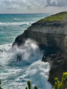 Puerto Rico’s East region is its adventure and nature capital – the wettest and greenest corner of the main island and the launch point for its offshore treasures. Here rises El Yunque National Forest, the only tropical rainforest in the U.S. National Forest System, with its waterfalls, cloud-draped peaks, and hiking trails. The coastline around Fajardo and Luquillo offers marinas, reef-fringed cays like Icacos, the beloved beach kiosks of Luquillo, and the glowing waters of Laguna Grande, one of the island’s bioluminescent bays. Ferries and small planes reach Vieques – home to Mosquito Bay, recognized as the brightest bioluminescent bay in the world, plus wild horses and former Navy lands turned wildlife refuge – and Culebra, whose Flamenco Beach ranks among the finest anywhere. Inland, the Turabo Valley city of Caguas and the Afro-Puerto Rican cultural heartland of Loíza (famed for bomba music and the Fiestas de Santiago Apóstol) round out a region where rainforest, coast, and island life meet.
Municipalities
- Caguas
- Canóvanas
- Ceiba
- Culebra
- Fajardo
- Gurabo
- Humacao
- Juncos
- Las Piedras
- Loíza
- Luquillo
- Maunabo
- Naguabo
- Río Grande
- San Lorenzo
- Vieques
- Yabucoa
Central Mountains Region (Región Montañas Centrales)
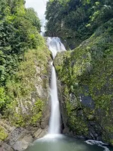 The Central Mountains region is Puerto Rico’s rugged, cooler heart, where the Cordillera Central rises to Cerro de Punta – at roughly 4,390 feet the island’s highest peak – and temperatures can run 10 to 15 degrees cooler than the coast. This is coffee country, its slopes terraced with haciendas around Jayuya, Adjuntas, and Utuado, and its ridgelines traced by the Ruta Panorámica, a scenic route that stitches together forest reserves, waterfalls, and sweeping viewpoints. The region safeguards Puerto Rico’s Indigenous roots: Utuado’s Caguana Ceremonial Center preserves Taíno bateyes (ball courts) and petroglyphs, while Jayuya celebrates its Indigenous heritage each November. Mountain towns each offer their own draw – Barranquitas as the “Cradle of Patriots,” Aibonito with its cool climate and famous flower festival, and Orocovis, the geographic center of the island, now a hub for ziplining and off-road adventure. With misty peaks, creole cuisine, and a slower rural rhythm, the Central Mountains reveal an interior world far from the beaches.
Municipalities
- Adjuntas
- Aguas Buenas
- Aibonito
- Barranquitas
- Cayey
- Ciales
- Cidra
- Comerío
- Corozal
- Jayuya
- Morovis
- Naranjito
- Orocovis
- Utuado
South Region (Región Sur)
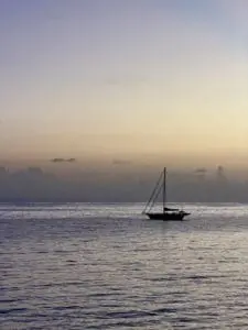 Along the Caribbean coast, the South region basks in the island’s driest, sunniest climate – a landscape of scrubby dry forest, salt flats, and warm turquoise water very different from the lush north. Its crown is Ponce, “La Perla del Sur,” a graceful city of neoclassical architecture centered on Plaza Las Delicias, the candy-striped 1882 Parque de Bombas firehouse, the acclaimed Museo de Arte de Ponce, and the hilltop Castillo Serrallés overlooking the sea. Nearby, Coamo draws visitors to its natural thermal hot springs, Salinas is prized for its fresh seafood and mojo isleño, and Juana Díaz is known island-wide for its Three Kings traditions. The coastline offers marinas, the boardwalk of La Guancha, and boat trips to the island of Caja de Muertos. Shaped by a rain shadow cast by the central mountains, the South is Puerto Rico’s warm, historic, and often overlooked side – rich in colonial architecture, festivals, and Caribbean light.
Municipalities
West Region (Porta del Sol) (Región Oeste)
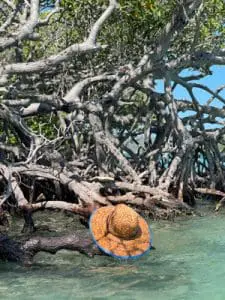 Puerto Rico’s West region – marketed as Porta del Sol – is the island’s coast of surf and sunsets, where the Caribbean and Atlantic meet across the Mona Passage and the sky puts on a nightly show. Rincón is the undisputed surfing capital, drawing waveriders to breaks like Domes and Tres Palmas, whale-watchers in winter, and sunset-seekers year-round. To the south, Cabo Rojo offers the postcard cliffs and lighthouse of Los Morrillos, the pink-tinged salt flats, and the shallow, luminous water of Playa Sucia and Combate, while nearby Lajas is home to the La Parguera bioluminescent bay and its mangrove cays. The region blends coast and culture: Mayagüez, “the Sultana of the West,” anchors the area with its historic plaza and zoo; San Germán, the island’s second-oldest town, preserves the tiny 16th-century Porta Coeli chapel; and the Guánica dry forest, a UNESCO biosphere reserve, protects one of the best-preserved subtropical dry forests on Earth. Inland, coffee-and-citrus hill towns like Lares – birthplace of the 1868 Grito de Lares – and Maricao add mountain character to a region best known for its beaches, reefs, and laid-back rhythm.
Municipalities